Log in
All resources
Create a design
1,658 Free Images of World Map
maps
planet
globe
geography
continent
cartography
planet earth
earth
countries
global
water
maps
planet
maps
space
maps
travel
maps
planet
maps
travel
maps
planet
maps
space
maps
planet
maps
low poly
maps
science
maps
planet
maps
history of antwerp
renaissance
maps by willem and johannes blaeu
atlas van loon
planet
maps
travel
maps
planet
maps
planet
maps
planet
maps
planet
maps
low poly
maps
planet
maps
afonso v of portugal
fra mauro map
business
maps
planet
maps
planet
maps
symbol
bird
planet
maps
low poly
maps
planet
maps
background
maps
planet
maps
planet
maps
diego gutiérrez
renaissance
old administrative maps of the ottoman empire
1909 maps of asia
maps
ball
travel
maps
low poly
maps
low poly
maps
children
maps
symbol
maps
1474 maps
1928 maps
1640s maps of the world
1660s maps of the world
bird's-eye views of paris
engravings of paris
maps by edward wright
molyneux globes
old maps of the british empire
illustrations by walter crane
18th-century double hemisphere world maps
1720s maps of the world
illustrated title pages
1645 books
maps by nicolaes visscher i
prints by nicolaes berchem
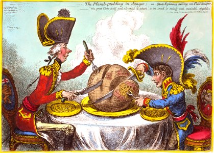
the plumb-pudding in danger (cartoon)
1805-02-26
maps
tree
1690s maps of the world
copper engravings
maps by thomas kitchin
andrew dury
maps made in the 16th century
johannes ruysch
details of old maps of the world showing "aquita" in japan
johannes baptista vrints
may 2023 in venice
fra mauro map
alphabet charts
lord's prayer
1590s maps of the world
1595 maps
maps of the world with orthographic projection
maps of the world without antarctica
1520s maps of the world
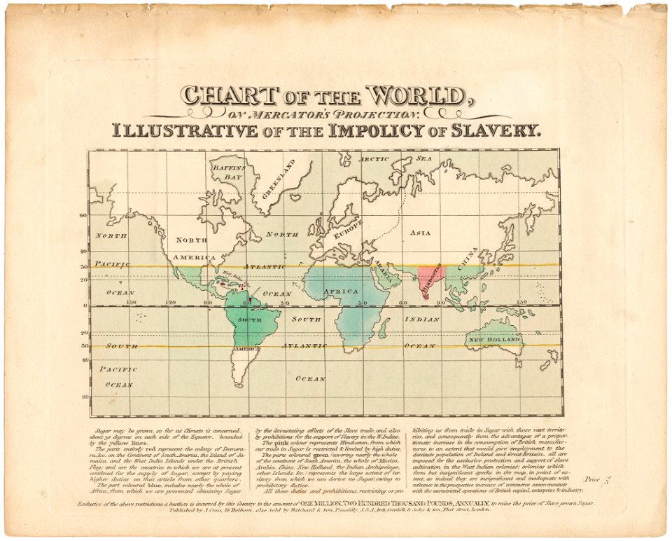
propaganda map
maps by willem and johannes blaeu
old maps with mercator projection
world war ii posters from the united kingdom
her majesty's stationery office collection
fra mauro map details
old maps of thailand
le panorama, exposition universelle
engravings of paris
maps by edward wright
molyneux globes
the geographical distribution of animals (book)
zoogeography
edward wright (mathematician)
maps by jodocus hondius
maps with figures
michael burghers
maps by willem and johannes blaeu
1660s maps of the world
old maps of the tsardom of russia
clothing of russia
cornell: persuasive cartography: the pj mode collection
economic maps of the world
maps by jodocus hondius
1595 maps
oil paintings of the royal museums greenwich
realism
willem schouten
willem blaeu
beschreibung der städt der welt - braun & hogenberg - btv1b52512111k
maps of munich by braun & hogenberg
maps of the league of nations
1929 maps of the world
maps in the rijksmuseum amsterdam
maps by frederick de wit
claes jansz. visscher (ii)
1650s maps of the world
maps by john cary
1801 maps
maps of the world without antarctica
1820s maps of the world
cornell: persuasive cartography: the pj mode collection
maps of continents
jodocus hondius ii, nova totius terrarum orbis geographica ac hydrographica tabula, 1636
eran laor cartographic collection
maps by willem and johannes blaeu
novus atlas blaeu
1800s maps of the world
old maps of the world
jodocus hondius ii, nova totius terrarum orbis geographica ac hydrographica tabula, 1636
eran laor cartographic collection
jodocus hondius ii, nova totius terrarum orbis geographica ac hydrographica tabula, 1636
eran laor cartographic collection
jodocus hondius ii, nova totius terrarum orbis geographica ac hydrographica tabula, 1636
eran laor cartographic collection
jodocus hondius ii, nova totius terrarum orbis geographica ac hydrographica tabula, 1636
eran laor cartographic collection
terra australis
padrón real
nypl lionel pincus and princess firyal map division
geographical atlases
island of california on world maps
1650s maps of the world
atlas maior, vol 1 (northern europe, norway, and denmark) - joan blaeu, 1667 - bl 114.h(star).1
17th-century double hemisphere world maps
1650s maps of the world
age of discovery
dutch baroque architecture
1740s maps of the world
maps by hendrik hondius the younger
1640s maps of the world
beschreibung der städt der welt - braun & hogenberg - btv1b52512111k
maps of weimar by braun & hogenberg
beschreibung der städt der welt - braun & hogenberg - btv1b52512111k
maps of tangier by braun & hogenberg
dutch baroque architecture
1740s maps of the world
1510s maps of the world
german renaissance
1690s maps of the world
maps by carolus allard
101 - 200 of 1,658
Next page
/ 17